Haywards Heath II
As the M25 skirts the North Downs south of London and the A27 skirts the South Downs and Brighton the A272 traverses the ancient home of Haywards Heath, the High Weald of Mid-Sussex. Heather Warnes 2009 history observes that ‘it was common in this part of Mid Sussex for early estates to be laid out across a ridge top, the north-facing slopes often being reserved to the lord for wood and timber’. The heath was open land facing south benefitting both from the sun and drainage of water from the rock underlay of the High Weald down to the southern claylands. The River Ouse north of the Weald provides a second natural boundary for our heath.

Haywards Heath is a town with population 33,845 (2011 census) that grew up to the north and east of the ancient ‘Hayworth’ estate after the arrival of the railway in 1841. Its name derives from ‘Hayworth’ south of Muster Green on the A272 formerly a prehistoric ridgeway track. In her ‘Assessment of the early history of Hayworth and Trubwick in Haywards Heath’ (2009) local historian Heather Warne describes how Hayworth and Bolnore were part of the manor of Trubwick north of the Saxon estate of Keymer which ran south to the Downs. The former Roman Road from Hassocks to London ran north through the west of Hayworth making a cross roads with the ancient ridgeway at Beech Hurst.
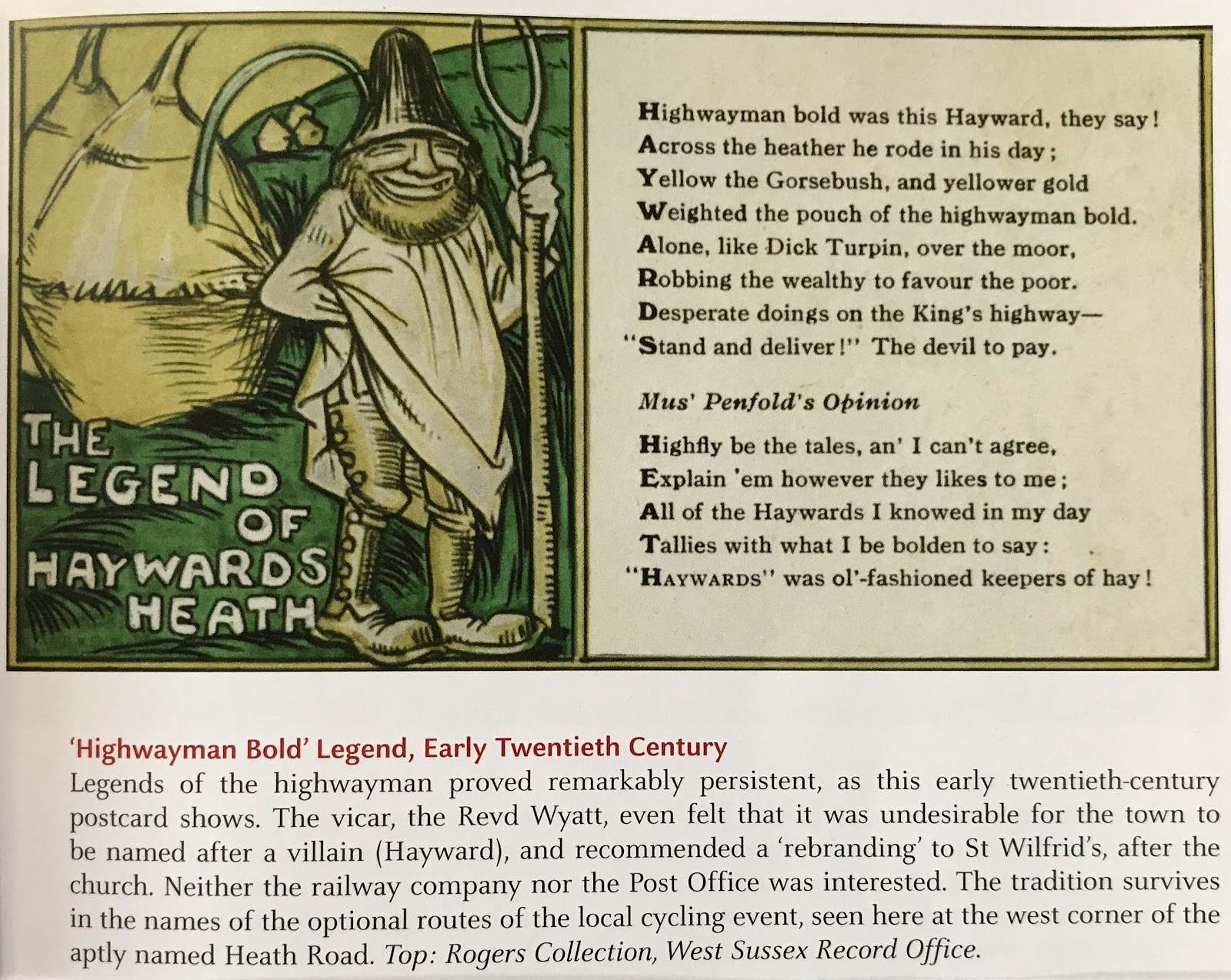
Nasty experiences with highwaymen on Haywards Heath, the ‘hoth’ or wasteland outside Cuckfield and Lindfield, are part of folklore to the extent of the seeming invention of a fearsome Jack Hayward who once ruled it to whom you had to ‘stand and deliver’! This romantic legend got under the collar of a Vicar of St Wilfrid’s who put in an unsuccessful bid to rename the town ‘St Wilfrid’s’. The legend postcard displayed in Colin Manton’s ‘Haywards Heath Through Time’ (2003) is despatched by references to Hayworth Hoth going back to the 13th century. Hayworth derives from old English words about an enclosure of land and there is 17th century evidence for this enclosing.
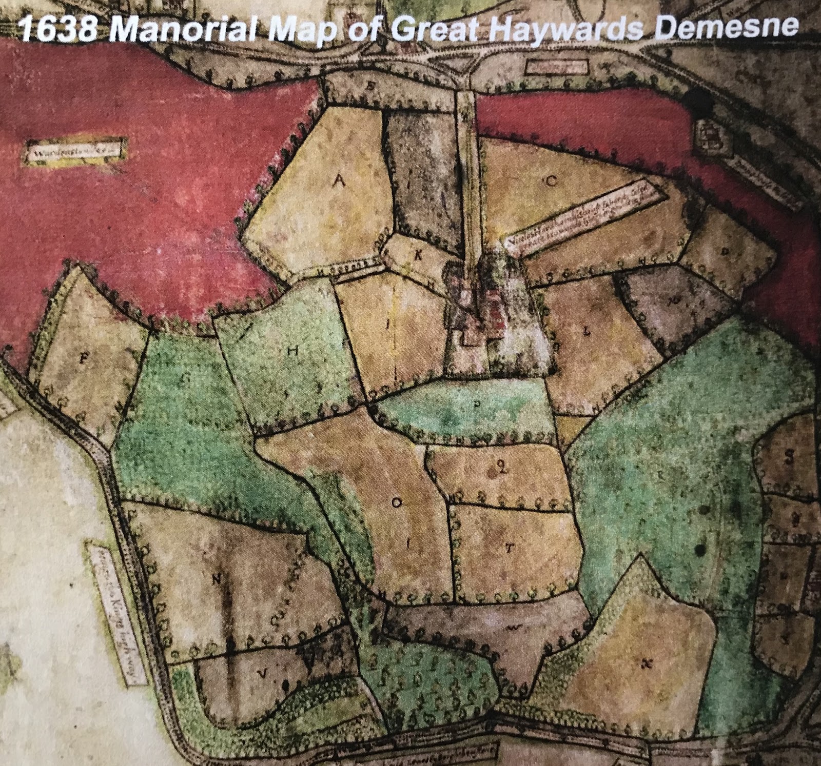
This attractive 1638 map published by Haywards Heath Society was used in Stuart Meier’s 2006 submission to the Bolnore Village Planning Inquiry as evidence ‘that certain wooded parcels have ancient woodland continuity, and the effects of development should be mitigated in an appropriate manner’. The beautiful and highly detailed map of land belonging to ‘Nicholas Hardham and his heiress’ can be accessed at the West Sussex record office at 3 Orchard Street, Chichester. On close inspection you find the familiar names of Butlers Green House, Steeple House, Muster Green, Boltro Farm and the building now Miller & Carter’s Steakhouse, previously from 1845 ‘The Sergison Arms’, from 1832 ‘The Dolphin’ and on the 1638 map a farm ‘Hen Davis House and Lande’.

Butlers Green House mentioned on the 1638 Haywards map and home from the 17th century of the Warden family whose name has been applied to the local Warden Park schools. Colin Manton’s ‘Haywards Heath Through Time’ (2003) recounts ‘according to legend, a ‘lady in grey’ haunted the closed gate at the front. The old chain could be heard rattling when she appeared. It was said she was banished by her husband, who was convinced that she had taken a lover. She fled in darkness with her infant child in her arms and fell into the pond. Tragically they drowned.’ The deep pond at Butler’s Green has long ago been filled in!

Steeple Cottage in Haywards Heath gets mentioned on the 1638 Hayworth map as a Court House. Later in 1851 it belonged to a carpenter named Thomas Jenner. In 1973 Mid Sussex Times interviewed Bert Manvell whose family had moved into the Cottage in 1903. Bert describes in his childhood ‘listening for the teams of cart horses with their bells as they approached along the road, and then running with them to the Dolphin (now Miller & Carter’s Steakhouse). “I have seen as many as six teams, with nose bags on, hitched to the three large oaks which stood in front of the hostelry”, he said. “Having seen them, I would look in on old Tom Green and Jack Sayers at the forge next to the pub’.

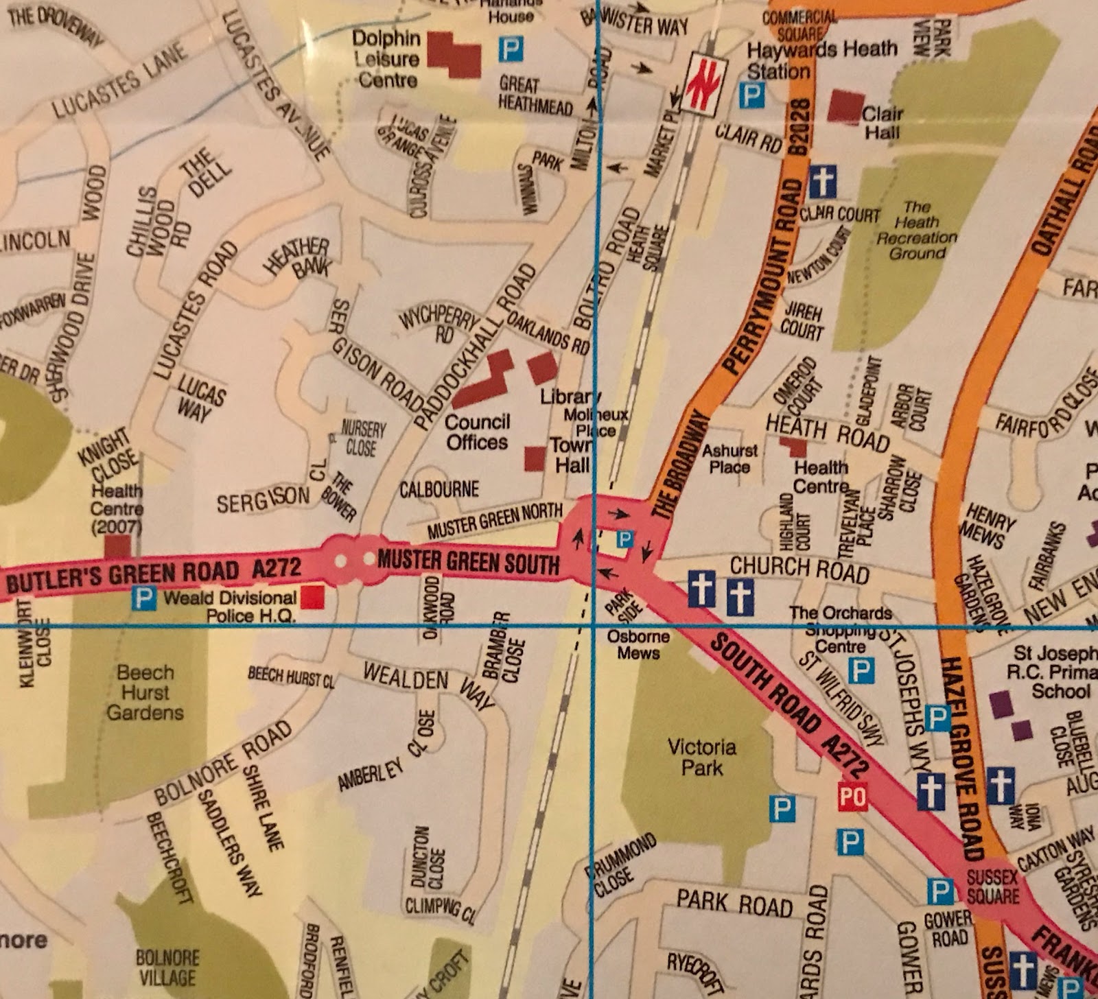
Boltro Farm shown in Smith’s ‘Haywards Heath in old picture postcards’ (1993) stands at the junction of Boltro Road and Muster Green Road. Both road names have, like the farm, animal association as boltro is short for ‘bull trough’ and the mustering of animals on Muster Green goes back to a 13th century charter renewed by Charles II granting permission for annual fairs in April and November for the sale of livestock. The original lands of Boltro Farm host the main buildings of Haywards Heath town centre including the Town Hall and main Council buildings. Boltro Farm fell into serious dilapidation at the end of the 19th century to be rescued in the early 1900s.

Muster Green (1910) shown in Smith’s ‘Haywards Heath in Old Picture Postcards’ (1993). It's one of the oldest historical sites in Haywards Heath being the northern boundary of the ancient ‘Hayworth’ enclosure shown on a map of 1638. The new town sprang up west of Muster Green after the arrival of the railway in 1841. Today it's the site of the town’s war memorial. What was mustered? Animals according to a 13th century charter but the battle of Haywards Heath in 1642 gathered troops here, Royalists from Chichester to fight puritan Lewes folk. The Roundhead victory was a turning point in the English Civil War denying King Charles I’s forces access to Lewes and south coast ports.

Muster Green in Haywards Heath changed character on November 30th 1924 when Lord Leconsfield unveiled the Haywards Heath war memorial to replace a temporary provision at the town’s ancient road junction. With the appalling slaughter of World War One fresh in so many memories hundreds are seen here gathered for the ceremony. The enormous memorial took the form of a seven and a half ton granite slab from Penrhyn in Cornwall. It was inscribed with 167 names. A memorial to all 6,709 men from the Royal Sussex Regiment who died 1914-1918 is provided by the specially dedicated Chapel of St George in Chichester Cathedral.

Smith’s ‘Haywards Heath in old picture postcards’ (1993) captures a Hunt assembling outside The Sergison’s Arms which is now Miller & Carter’s Steakhouse on the roundabout at the west of Muster Green. A century ago there would be plenty of open countryside for the now forbidden pursuit of fox hunting. The pub name links to Charles Sergison who bought Cuckfield Park in 1691 after a naval career and whose descendants owned the Park until its sale in 1968. Sergison’s arms included a Dolphin crest and his family’s influence on Haywards Heath is celebrated by the naming of the Dolphin Leisure Centre (1976). In recent years the pub was briefly renamed ‘The Dolphin’ like the centre which confused residents!
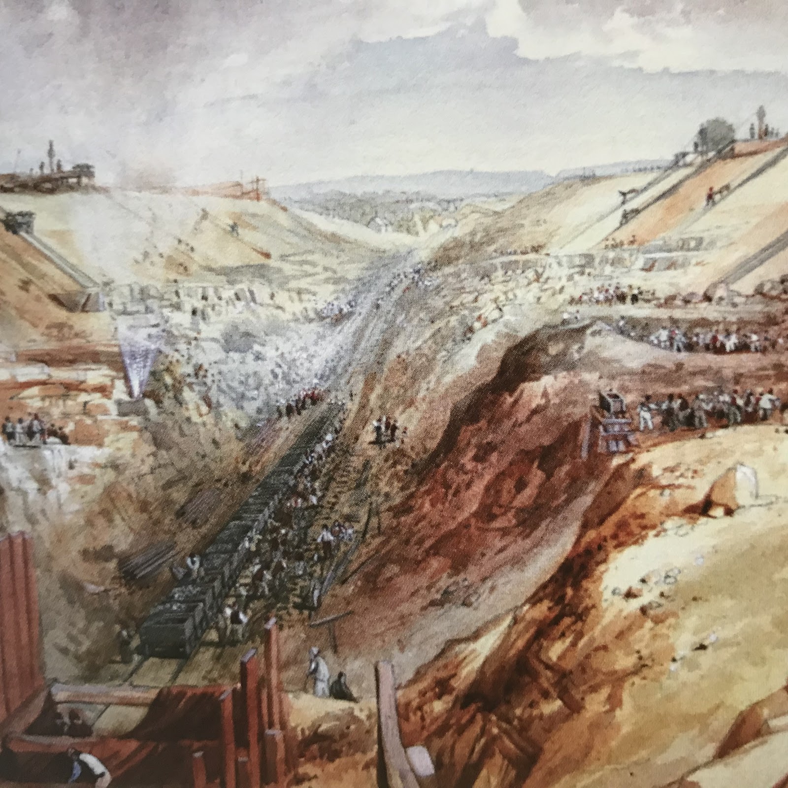
When London discovered Brighton a railway was born - and so was Haywards Heath! George Childs’ watercolour in Cuckfield Museum dated 1841 shows them digging the railway tunnel under Muster Green in Haywards Heath. Visible in the foreground is construction of the ventilation towers one of which is clearly visible off Muster Green. Getting trains to Brighton now known as London-by-the sea brought 5,000 workers and 50 horses to Haywards Heath to make the tunnel. It was a genuine Heath then but due to railway phobia in neighbouring Cuckfield and Lindfield it landed the railway to become the strategic heart of Sussex. I came to Haywards Heath 2001 with an across Sussex posting travelling at minimum cost to Brighton, Chichester, Crawley and Rye.
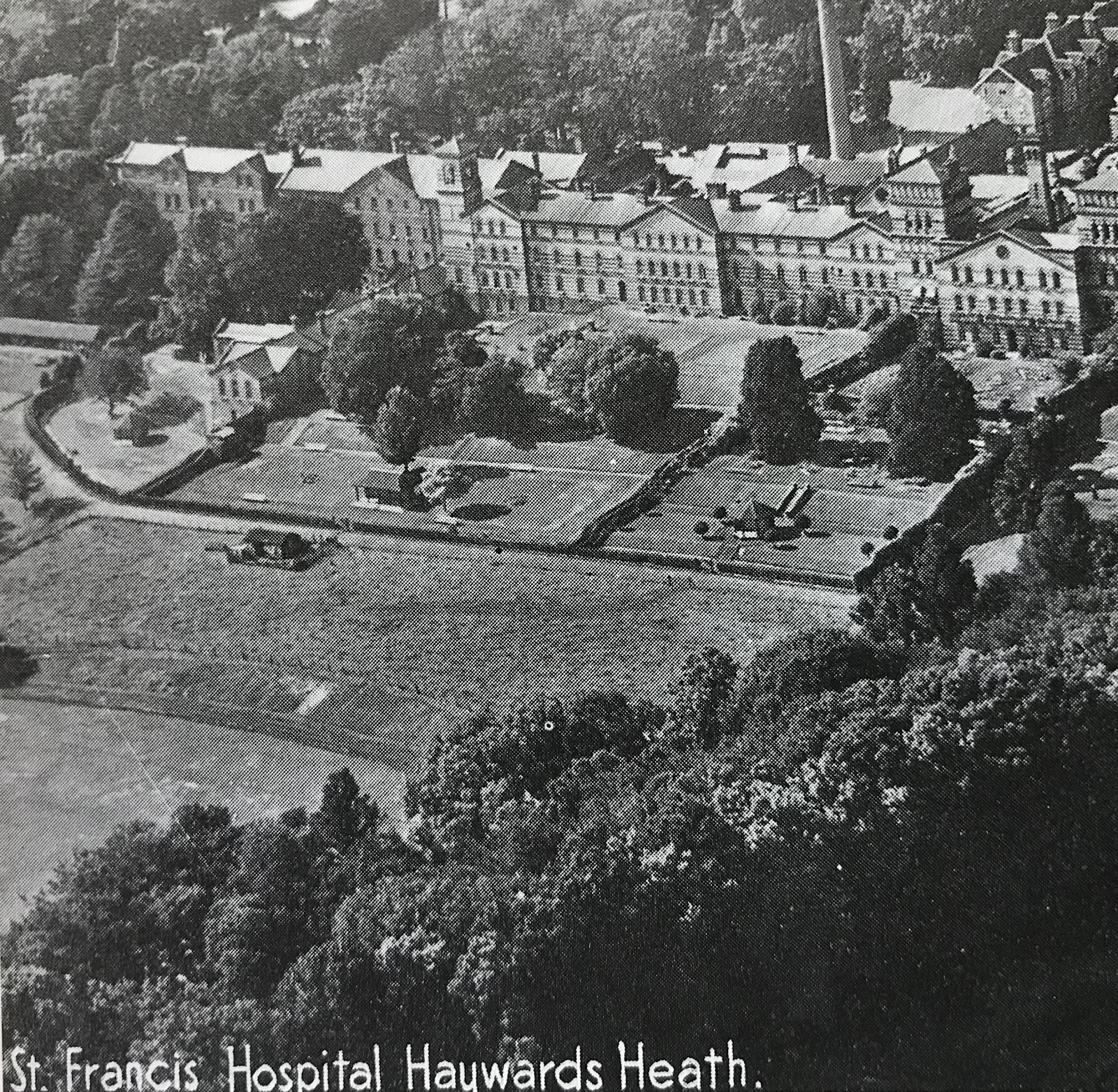
The railway’s arrival in Haywards Heath at the centre of Sussex made it the obvious venue for the County Lunatic Asylum constructed during the 1850s and known after the introduction of the National Health Service as St Francis Hospital. Treatment of mental illness in Victorian times differs so much from in our day with isolation seen as the key for fear almost of contamination. The population of Haywards Heath in 1883 was 1,814 but this figure excluded roughly the same number in the colony south east of the town which had its own farm. The story of the asylum now converted into apartments is told in ‘Sweet bells jangled out of tune’ by James Gardner (1999).
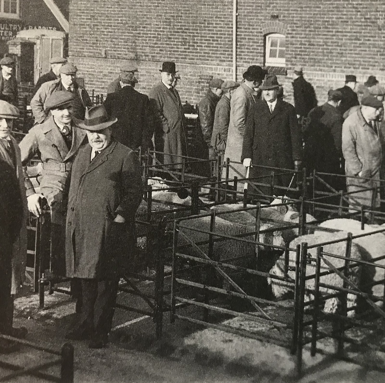
Hot on the heels of the arrival of Haywards Heath railway station in the 1840s came the establishment of the cattle market in the 1860s. It was situated by the western entrance to the station which we now know as the reopened side entrance later moving 300 metres north to a site now covered by Sainsbury’s superstore. This picture of Bannisters Livestock Market c1930 is from Smith’s ‘Haywards Heath in old picture postcards’ (1993). Closed in 1989 the eight-acre site handled the sale of up to 100,000 head of stock a year at what was once one of the twelve largest livestock markets in Britain. On market days a farmyard smell permeated the town as over 100 cattle lorries arrived.
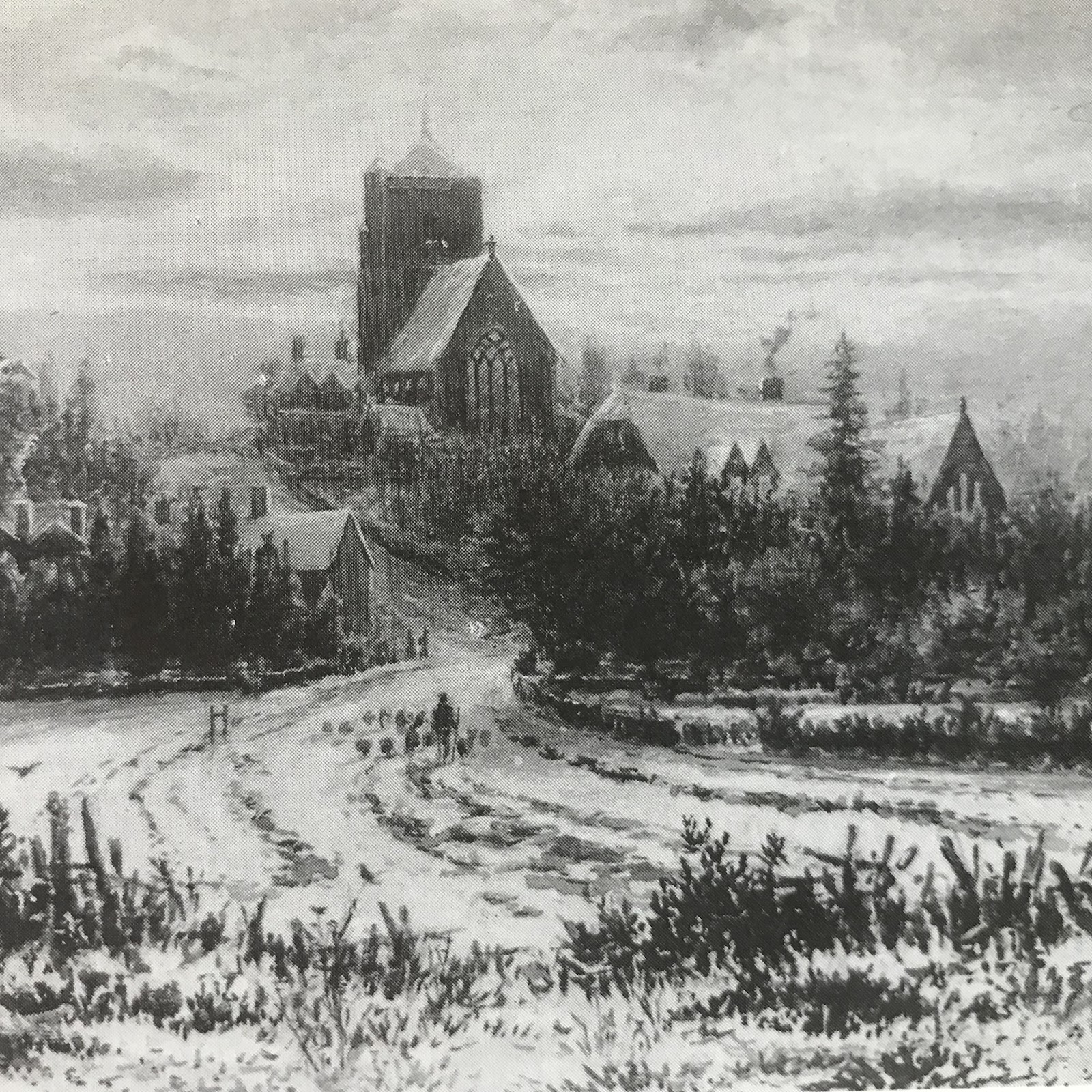
Fred Miller’s painting of Haywards Heath’s parish church of St Wilfrid in winter 1880 uses artistic licence to emphasise its prominence. As the commentary on this picture in Smith’s ‘Haywards Heath in old picture postcards’ (1993) states ‘built on the highest ground in the town, it's cornerstone was laid on St Wilfrid’s Day, 12 October 1863. It was built by Mr. Fabian to the design of the renowned ecclesiastical architect G.F.Bodley, with stone contributed by Mr. Tyler from his quarry on the Scaynes Hill Road. The Misses Dealtry of Bolnore House were generous donors’. Reverend Robert Wyatt was the first parish priest serving for 35 years succeeded by his son who was parish priest for a further 39 years.
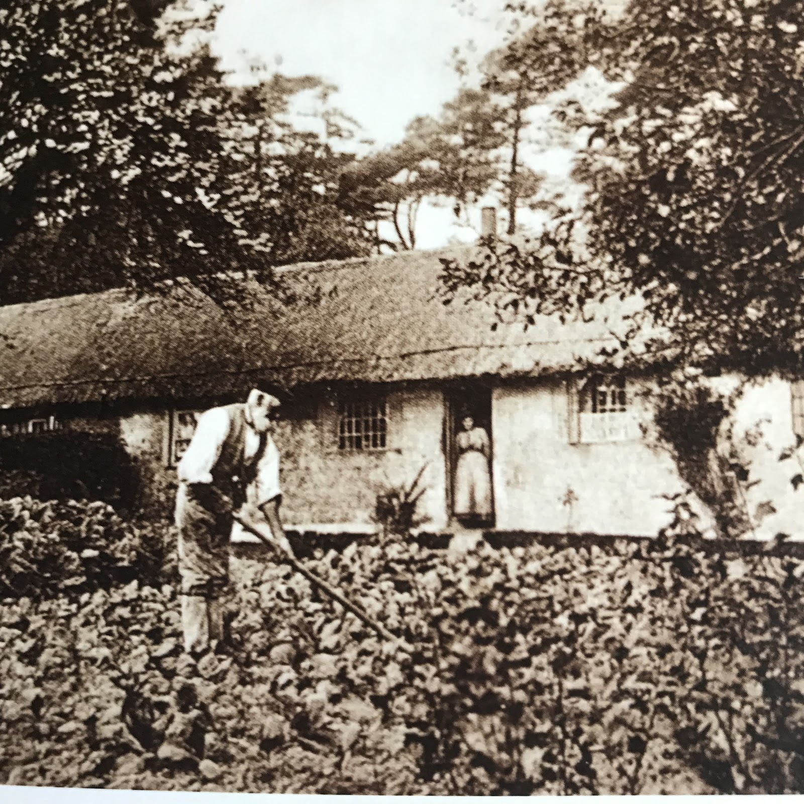
This picture from Colin Manton’s ‘Haywards Heath Through Time’ is of Gravelye Cottages in 1911. Quaker philanthropist William Allen (1770-1843) visited Lindfield in 1821 noting it to be ‘the poorest, most neglected village he had ever seen’. Emigration was then a popular ‘solution’ to reduce the cost of poor relief but Allen insisted ‘instead of encouraging emigration at an enormous expense per head let that money be applied in the establishment of Colonies at Home and the increase in our national strength’. Allen built Gravelye cottages to be rented with land for crops to Lindfield’s poor as part of what came to be the ‘American Colony’. These wattle and daub cottages were demolished mid 20th century with loss of an extraordinary part of local heritage.

America Lane (1910) with the Colony fence then retaining a rural idyll. The three ‘Rediscovering America Local History’ booklets are available in Haywards Heath library and are fruit of a group from the Bentswood estate meeting together in winter 2000/2001 to share memories and photographs at the Presentation Church Hall. Quaker William Allen created the ‘America Colony’ where Barn Cottage Lane is around 1830 to help the poor of Lindfield stay off parish relief. The analogy with emigration to America is preserved in the street names of later housing starting from 1878 up New England Road. In those days there was a gate for vehicular access at the bottom of this road with single-storeyed thatched cottages on the right beyond the gate.

This picture from Smith’s ‘Haywards Heath in old picture postcards’ (1993) taken around 1900 is a view from New England Road (built from 1878) up what was to be Western Road. Then it was a track through Petland Wood and there is not as yet a house in sight. ‘The story of New England Road’ (Edited Debbie Matthews 2001) records ‘as Western Road is so steep flat metal shoes would be slipped over a cart’s wheels to brake the speed in order to slow the horses going down. The cemetery in Western Road was created from Petlands Wood and part of it was consecrated for church people on 6 June 1917 as St Wilfrid’s churchyard had become full up and closed the following year’.
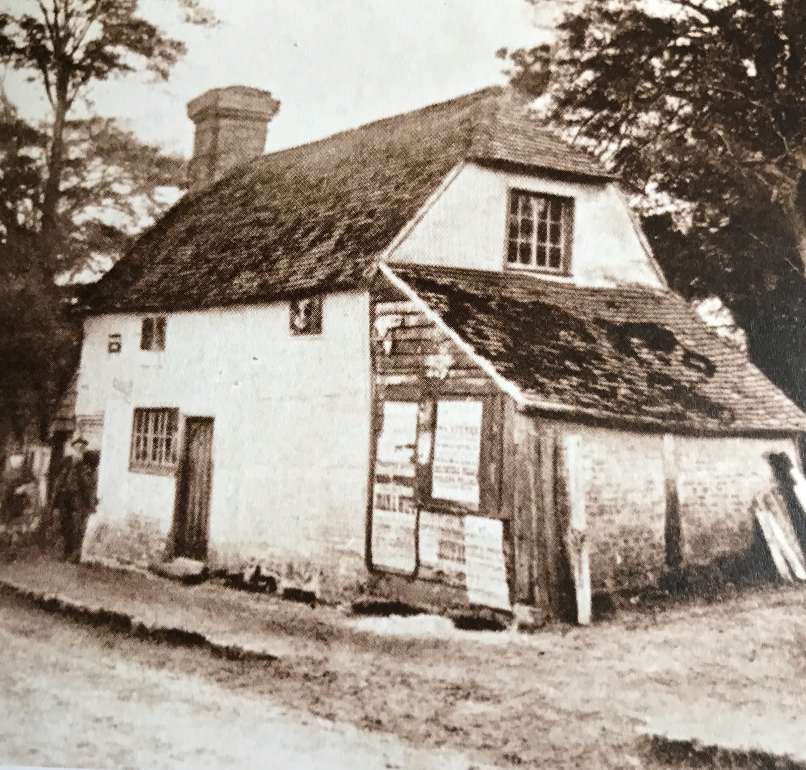
Dick Turpin’s cottage so-called was demolished mid-1880s to make way for the civic buildings on Bolnore Road. The legend concerning Haywards Heath being named after a highwayman called Jack Hayward seems to have been further embroidered by association with the notorious 18th century highwayman Dick Turpin. This tradition led the Vicar of St Wilfrid’s to put in an unsuccessful bid to rename the town ‘St Wilfrid’s’. Colin Manton’s ‘Haywards Heath Through Time’ (2013) notes how little credence other authorities gave to this tradition which led to a farm labourer’s cottage on the Sergison estate being so named. The quaint old cottage was unceremoniously demolished when an expanding Haywards Heath needed a courthouse and police station.
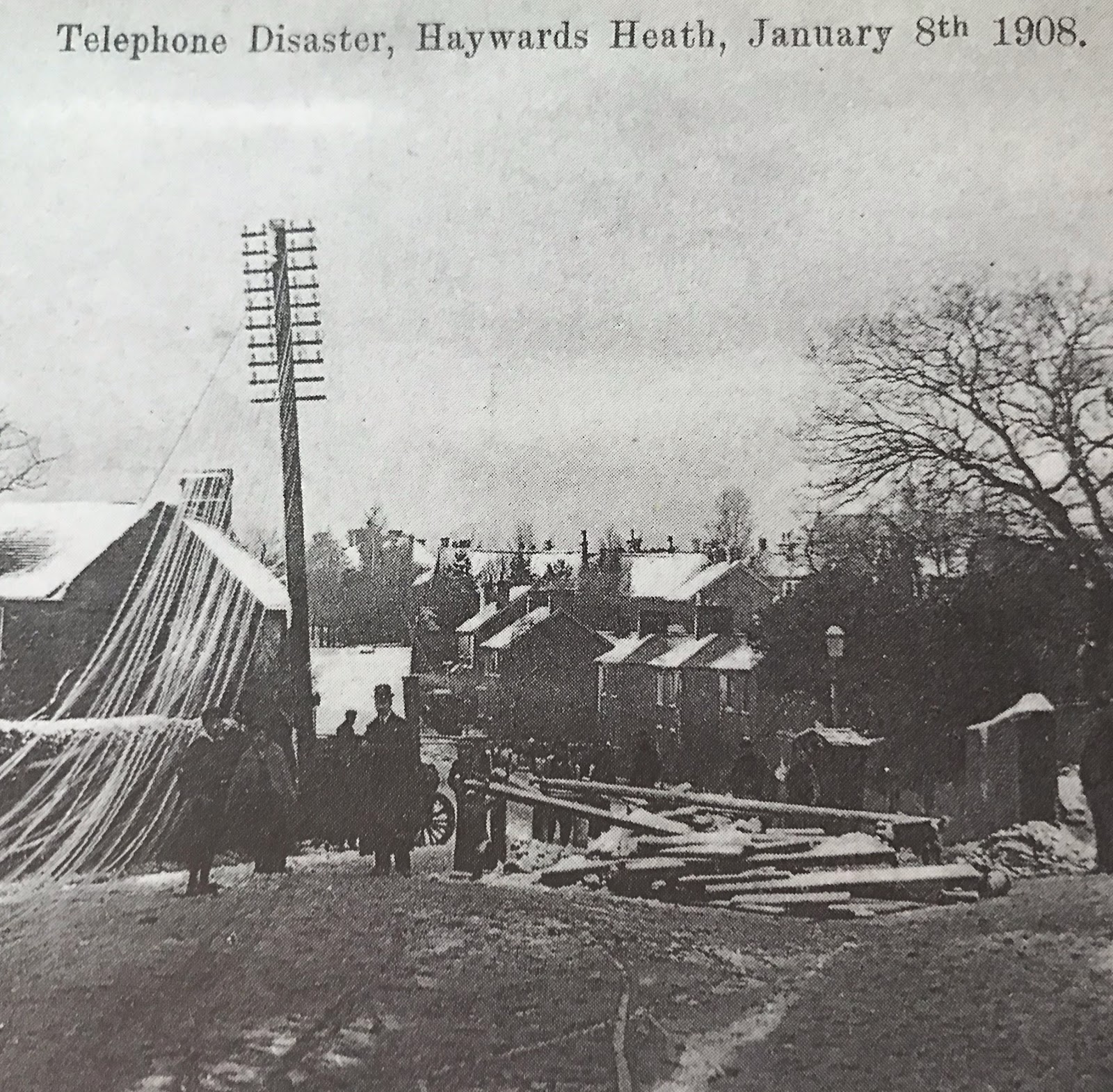
‘Haywards Heath in old picture postcards’ (N. Smith 1993) contains several ‘disaster’ cards which were commonly produced a century ago. As with today’s more extensive visual media the destructive power of nature is an eye and heart catcher provoking reflection and debate! This scene in Wivelsfield Road is set in 1908 when ‘a fierce blizzard swept through Mid Sussex. Gale force winds sent tiles flying and brought down snow-laden trees and telegraph poles throughout the town. The havoc caused thirty smashed telephone standards and miles of trailing wires which offered dramatic possibilities to the photographer’.

This ‘disaster postcard’ from Colin Manton’s ‘Haywards Heath Through Time’ (2013) depicts a telegraph pole made victim of snow and gales in 1908. Telegraph communication came hot on the heels of the railway serving an increasingly vibrant town in which occasional loss of telephone services was a mini-disaster akin to loss of internet services today. The pole straddles the fence of what was then a Congregational Chapel in Wivelsfield Road. This building changed use to being St Edmund’s Church until 1966 when it became a scout hut. In 2010 it became the Mid Sussex Islamic Centre & Mosque. The history of this building is a witness to the growth in diversity of the population of Haywards Heath over the last century.
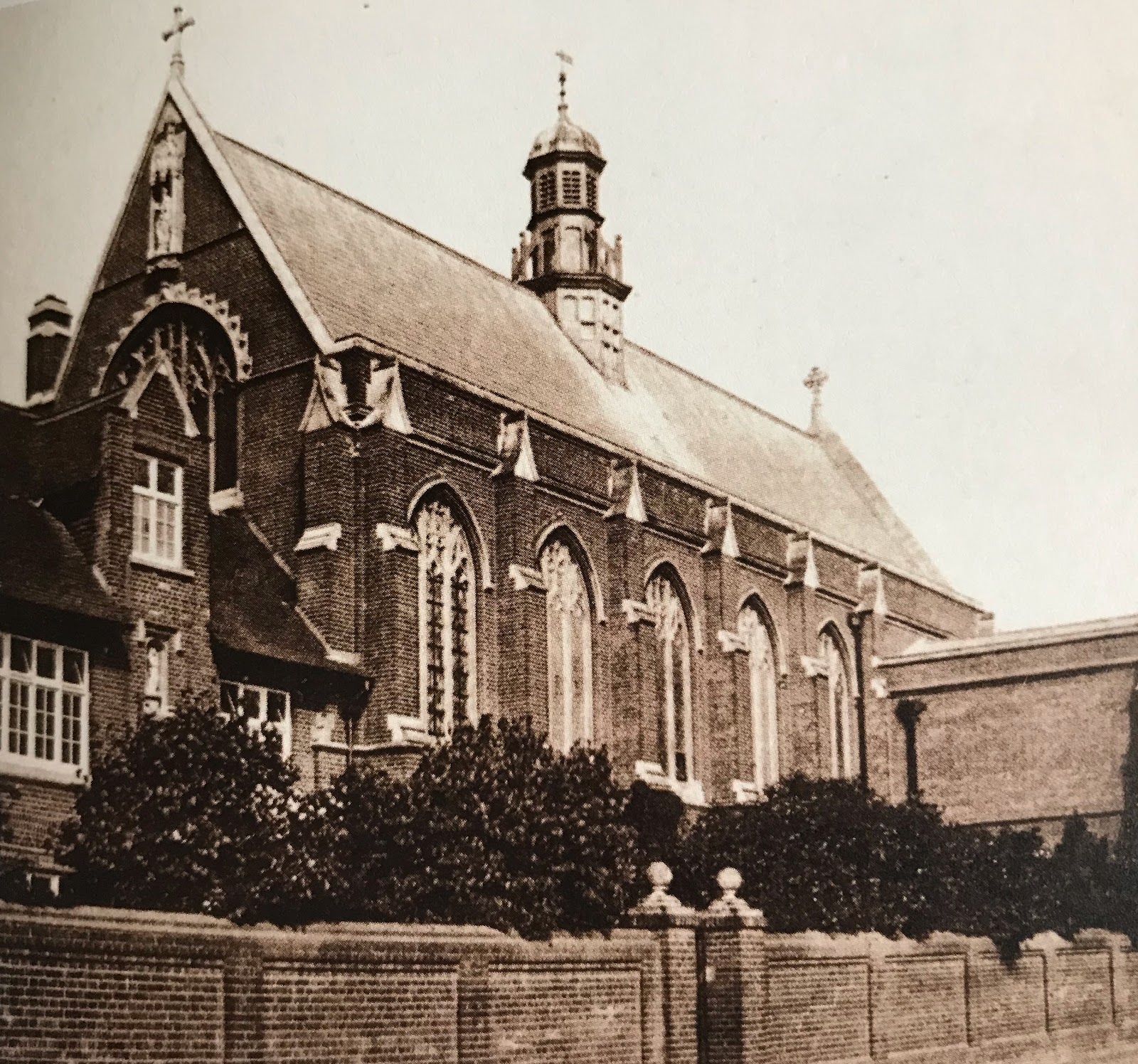
An octogenarian recalling his youth in Haywards Heath during the 1960s reflects on the rather severe dominance of the walled convent near the town centre from which he recalls there being occasional appearance of one nun pushing another in a wheelchair. By then the Priory of Our Lady of Good Counsel founded 1886 had dwindled as a community. The building of St Paul’s Church in 1930 meant local Roman Catholics moved from worshiping with the Canonesses Regular of St Augustine in the Priory’s south transept. The Order relinquished the Priory in 1977 and many walls came down to serve local housing development. The splendid building remains a notable feature on the skyline yet to find its best use.

The Tudor Gothic ‘St Clair’ formerly known as St Clair House was built for a Mr W.H.Kirkham in the 1880s. Older residents of Haywards Heath will recall its beautiful gardens over the tenure of the Ivatt family. A Miss Stevens, former head of the Girls’ Secondary Modern, succeeded them in 1936 and ran a private girls’ school in the house after much of the garden had been sold for development. ‘St Clair’ school, by then co-educational, closed in 1969 and the old house was demolished. The community centre known as ‘Clair Hall’ now stands on the playing field that was adjacent to St Clair, a social and cultural hub of the town aided by ample car parking facilities.

The Burrell Arms, Haywards Heath standing aloof and alone in 1886. A woodyard on the left is situated where the main station entrance and Waitrose now stand. Only the railway bridge is a familiar site. Frederick Ferguson took over the pub in 1878 advertising himself as a wine and spirit merchant in competition with the station and now extant Liverpool Arms. He advertised the Burrell Arms as a hotel with ‘good beds and sitting room’. In those days the pony chases, such as shown on the picture, were yet to give way to motor cars. This picture is from ‘Haywards Heath in Old Picture Postcards’ by Nickola Smith published 1993.
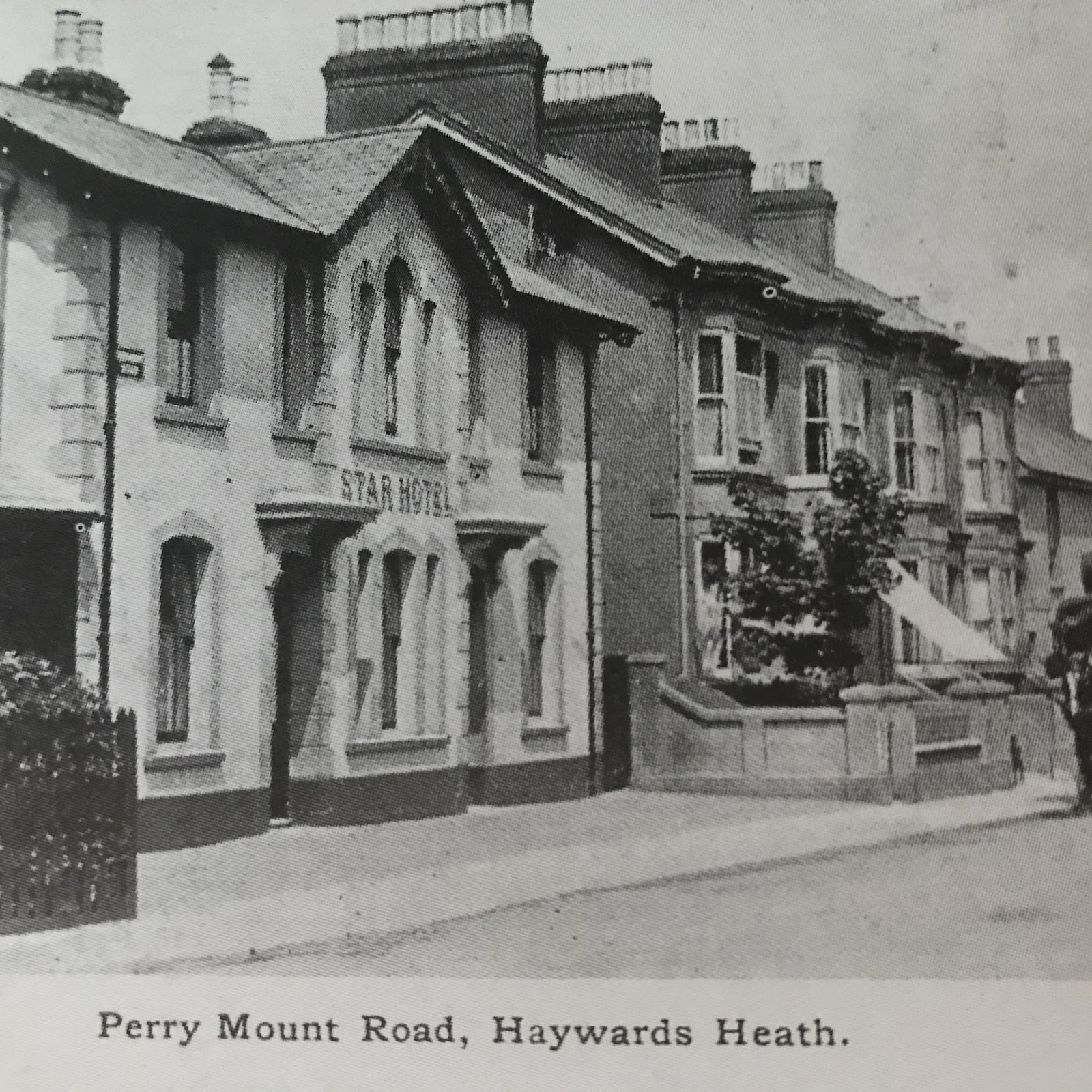
The Star pub in Haywards Heath shown around 1900 with the adjacent Clifton Terrace whose houses were then swiftly being turned into shops and businesses such as Humphrey the nurseryman, Flynn the cleaners and dyers and Richard Hayes dispensing chemist. The full picture in ‘Haywards Heath in Old Picture Postcards’ (1993) shows a tree-lined Broadway beyond. The east side of Broadway developed later in the 1920s. When this picture was taken St Wilfrid’s school lay opposite adjacent to the church and in consequence this was the busiest part of Haywards Heath.
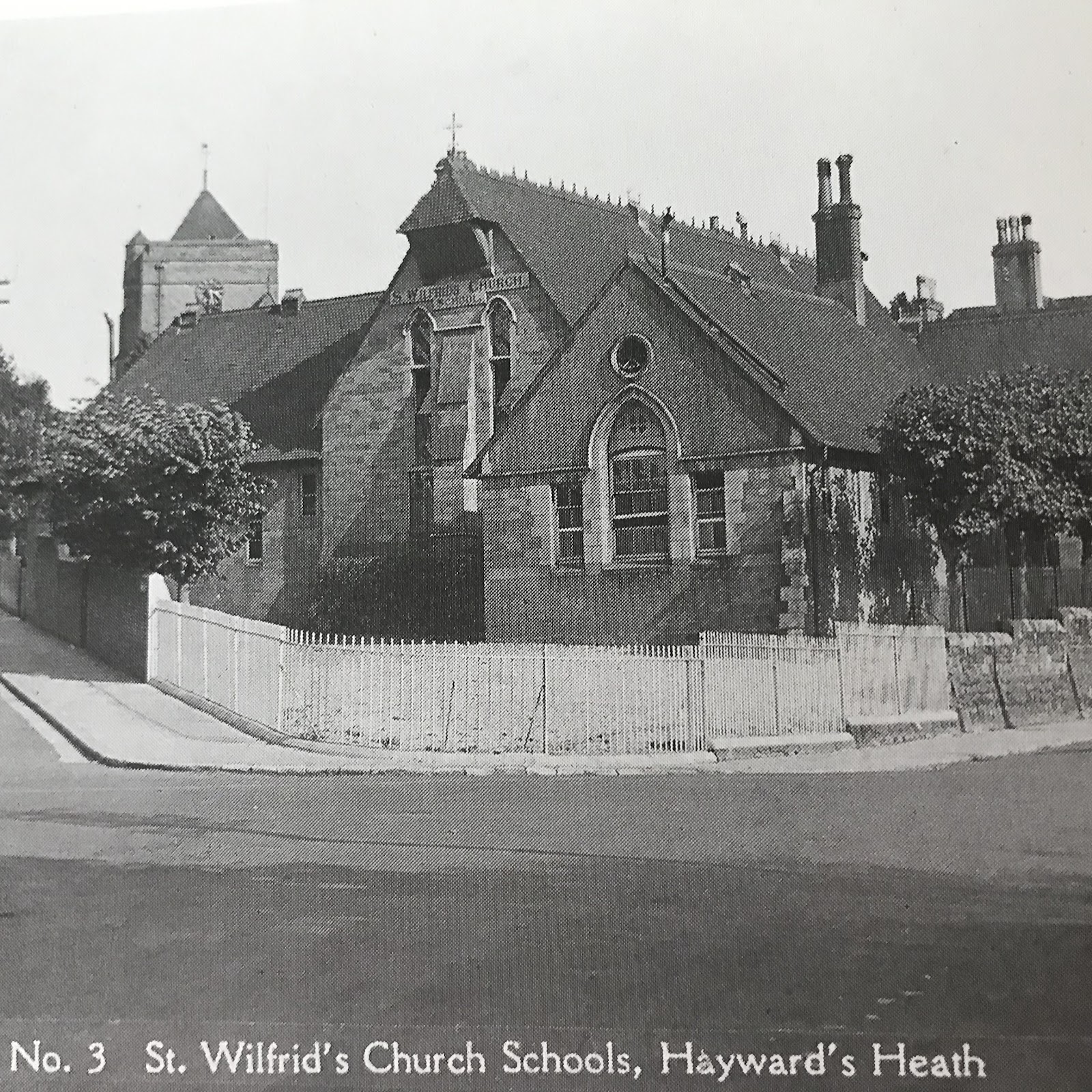
In ‘A Haywards Heath Chatterbox’ (2004) Lilian Rogers explains this picture taken around 1908: ‘A small triangular plot of land on the corner of, what is now, Church and South Roads was the site of a Church of England school built in 1857. There was, then, no church built, so worship was held within the school, and the latter was known as the Chapel School. However, 1863 saw the cornerstone of St Wilfrid’s Church being laid, and in 1865, the Chapel became St Wilfrid’s School… In order to cope with the town’s growth… in 1951 a new school was built in Eastern Road’. The school site was developed for shops and a Christian Science reading room which later became Zizzi’s restaurant.
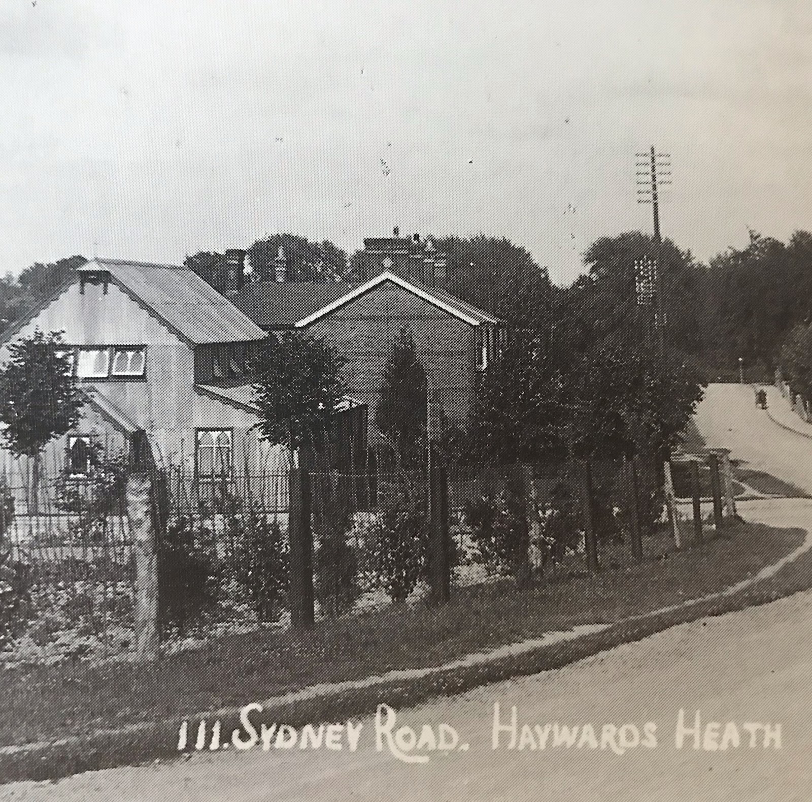
Sydney Road, Haywards Heath around 1910 showing the corrugated iron Chapel of the Holy Spirit nicknamed the ‘tin tabernacle’ which stood on land freed for housing by the demolition of Southlands Farm. Built 1897 to meet the needs of the fast growing population in the north of the parish the mission was made a conventional district under the patronage of St Richard in 1916. The temporary building was replaced by the familiar brick Church after decades of fundraising. The new St Richard’s Church was built on land that used to be the Vicarage tennis lawns by Norman and Burt of Burgess Hill. It was consecrated in 1930. This picture is from Smith’s ‘Haywards Heath in old picture postcards’ (1993)

This is all very interesting. My father attended Sharrow School on Heath Road during the war years. I was wondering if any photographs of the school existed. I did find film footage of a sports day held there in 1946 but photos of the former school would be lovely.
ReplyDelete